Latest version: 3.0, dated 2003.05.06
by Anders Kvalvaag / LA9NKA
Latest version: 3.0, dated 2003.05.06 |
[ 3712 ] | |
| A presentation of QRB & QTE, by Anders Kvalvaag / LA9NKA |
||
Introduction
Atlas Search
Printout / Export
Startup options
Download
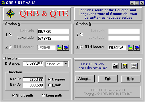
The program QRB & QTE is a simple tool to find the distance and directions between two given positons on the earth's surface. These two locations are referred to as Station A and Station B within the program.
When specifying the coordinates for the locations, they can be specified as either Degrees (decimal or degrees/minutes/seconds), or a QTH-locator (Maidenhead format).
There is also an Atlas Search feature in the program, from where one quickly can find predefined locations from two lists; a list of the amateur radio country prefixes, and a list of cities.
After having specified valid coordinates for both Station A and Station B, the resulting distance and directions are shown. One also has the choice of displaying the resulting distance in either kilometres, miles (us), or nautical miles, and the directions can be displayed as either degrees (0-360) or grads (0-400). One can also choose to have the results given for either the short or long path.
There is also online help available in the program, by either clicking the Help button, or pressing F1. In addition there is a "Quick help" system, which is invoked by clicking the right mouse button on a field (similar to that found in many Win95 programs).
![]()
This is what the main program window looks like (in
Win95):
![]()
The program also has an Atlas Search feature, which means one can search through a list of predefined locations.
There are two lists available, one containing the amateur radio DXCC prefixes, and one containing a list of towns and cities around the world.
The list of cities contains about 2500 locations, and this list can also be maintained by the user, by means of adding new locations, and edit or delete existing ones.
| When displaying the Atlas list of prefixes, one can change the sort order for the list, by clicking the appropriate option button in the bottom of the Atlas Search dialog. | 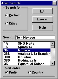 |
![]()
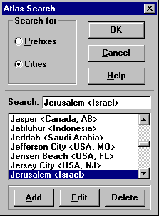 |
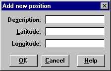
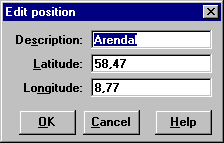
When displaying the Atlas list of cities, one can add new locations, edit existing ones, and delete existing ones. This is done by clicking the appropriate buttons in the bottom of the Atlas Search dialog, which in the case of adding or editing will display the following dialogs: |
 |
 |
![]()
| The program also has an option of making a printout of the amateur radio prefix list, with the azimuthal direction printed behind each prefix. When the program calculates the directions, it uses the location of Station A as the "starting point". | 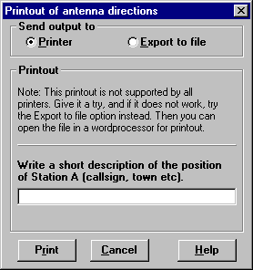 |
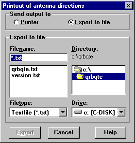 |
One can also export the list to a text file, using "semicolon delimited database format". The exported file can then, as an example, be imported into a wordprocessor or spreadsheet for further formatting and printout. |
![]()
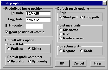
There are also a Startup options dialog in the program, from where one can set various startup defaults for the program.
From this dialog, one can specify a predefined "Home" location, which can be automatically read into the fields of Station A when starting the program. In addition, one can set the default measurement units for the results, and also some default settings for the Atlas Search.
This is what the Startup options dialog looks like (in
Win95):
![]()
Click on the download banner below, to go to the download page, from where one can download the program, and which also briefly describes the installation procedure.
![]()
| Page layout and design by Anders LA9NKA. Copyright © 1997-2011. Last update: 2011-04-27. |